Overview of Strategy
What is Green and Blue Infrastructure?
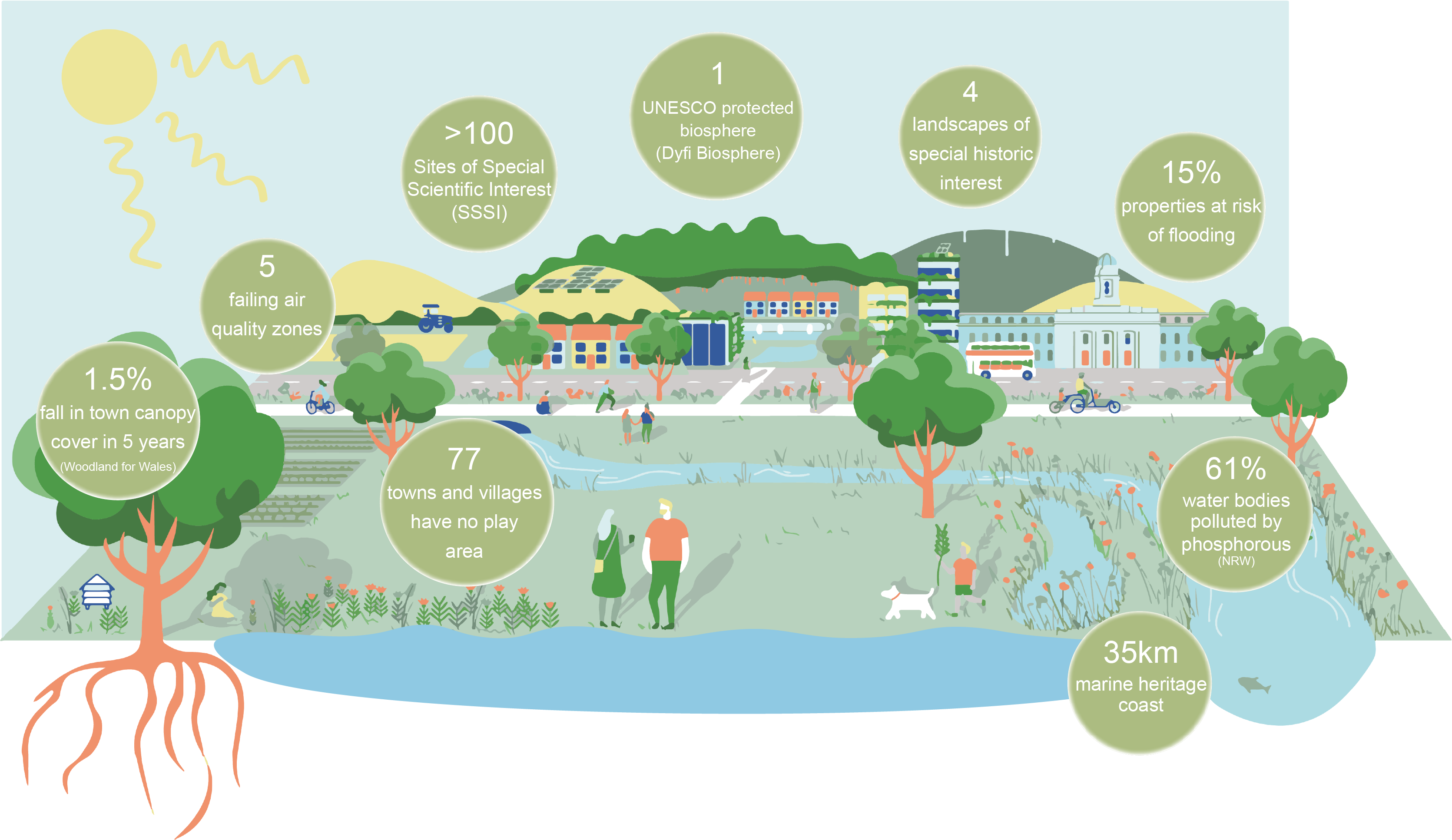
Ceredigion's GBI assets

Green and Blue Infrastructure (GBI) refers to the network of green and blue spaces that surround our towns and cities and weave through them. Just as a transport network connects people across an area through a network of roads, rail or pavements – GBI helps connect people, wildlife and nature.
GBI can include large green spaces like National Parks, Country Parks, farmed landscapes or river corridors. It can also include private gardens, allotments, hedges, street trees, roadside green verges, or footpaths.
The Wales Green Infrastructure Forum highlights the importance of GBI features serving ‘multiple functions’ when compared to ‘grey infrastructure’, which often serves only a single function. These might include transporting rainwater, removing water pollution, providing homes for wildlife, providing flowers for bees and other pollinators and helping to keep urban areas cool in the face of rising temperatures.
It is vital that GBI assets do not operate in isolation but should be linked to form part of a wider network. This helps them to withstand climate change and other impacts. It is equally important that the network threads through and around the built environment and connects the urban area to its wider rural hinterland.
Why do we need this GBI Strategy?
Given its spectacular setting, the natural environment in Ceredigion is at the heart of its identity. It also makes the County a key magnet for both residents and tourists. However, as the settlements within Ceredigion continue to expand, it is imperative that we protect this environment. We must ensure its ongoing resilience and maximise the mutual benefits of GBI for people, nature and place.
The evolving policy context in Wales means that greater attention is being given to green and blue infrastructure than ever before. In 2015 Welsh government passed the Well-being of Future Generations (Wales) Act 2015. The Act gives national and local government a legally-binding common objective to work together to improve the well-being of Wales. It does this by setting out seven well-being goals.
At the local level, there is significant ambition and support for making Ceredigion greener and more resilient. This Strategy hopes to progress these GBI ambitions and to prioritise a number of projects which can seek longer term funding. It will ensure that we are making the best use of resources in order to tackle the key issues and priorities highlighted through both data and stakeholder engagement.
This Strategy is just part of the County Council’s ambition for achieving a greener and more resilient Ceredigion.
It builds on the evidence set out within the 2020 Ceredigion Green Infrastructure Assessment (GIA) – which maps out green and blue infrastructure assets in Ceredigion and how they are connected. It also carries out an “audit” of GBI in Ceredigion’s urban environments.
The Strategy also sits alongside, and is informed by, other relevant plans, strategies and ongoing initiatives. Where relevant, these are referenced within the pages reviewing Ceredigion’s GBI Network Today.
What does the Strategy cover?
The GBI Strategy covers all categories of GBI assets in Ceredigion. This ranges from country parks, long-distance trails and river corridors, to gardens, road verges and ponds.
It focuses on six selected towns in the County – but also broadens its horizons to explore opportunities which may lie in between these towns, particularly where these opportunities would respond to identified key challenges.
The six selected towns are:
- The principal town of Aberystwyth.
- The coastal towns of Aberaeron and Cardigan.
- The inland towns of Lampeter, Tregaron and Llandysul.
These six Town Action Plans are accompanied by recommendations on the Delivery of the proposed GBI projects. This includes UK-based case studies of how a partnership approach can build a GBI network and highlights two recommended ‘delivery catalysts’ which the Council should explore.
What are the Key Principles guiding the Strategy?

Four Key Principles guided the development of this GBI Strategy. They provided a framework for the identification of opportunities and highlight the key functions that GBI features can deliver. They include:
- Making space for nature
- Shaping thriving public spaces
- Creating happy and healthy communities
- Strengthening resilience to climate change
How was the Strategy developed?

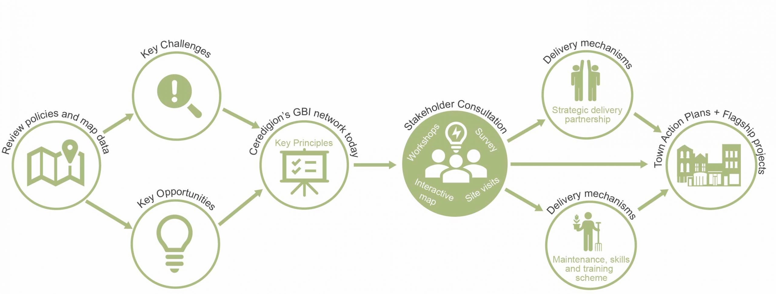
The GBI Strategy was prepared by:
- analysing spatial data on the existing network of GBI assets.
- reviewing existing relevant plans, policies and strategies.
- engaging closely with key national and local stakeholders.
This baseline work was used to identify the key challenges facing the GBI network within the six towns. It was then used to prioritise the most beneficial projects which can address these challenges.
Examples of these projects include proposals such as:
- the creation of wetland environments to combat flood risk.
- urban greening to enhance town centres.
- river restoration projects to manage flood risk and tackle water quality challenges.
- providing green corridors and walking/cycling routes to facilitate active travel.
A summary of the stakeholder engagement process is included in Appendix 2.
What happens next?
This Strategy, and the strategic projects it identifies, will form an important foundation for funding bids. These will be important in delivering prioritised projects across the six towns.
The projects outlined in each Town Action Plan set out the ‘strategic design’ principles that should be taken forward as part of these projects.
However, the Strategy does not set out the detailed design of each of these projects – for this to happen, further feasibility and design work will be required to enable these projects to be delivered on the ground.
Wide ownership and delivery of the Strategy will be crucial to its success. This should cut across all Council departments and go beyond them to take in wider stakeholders and a range of community groups (see Delivery pages).