Using the information
The results of this study are intended to be used in a number of ways, including:
-
Through identifying those areas that remain relatively free from light pollution, highlighting the importance of preserving the existing Dark Sky reserves in Wales, and helping to support new applications.
-
Promoting the benefits of dark sky friendly lighting and planning policies, linked to the context of the climate emergency and a lower carbon future.
-
To aid in aligning evidence and advice to positively inform planning application consultations, including an opportunity to target post Covid green recovery developments to consider light pollution in their design and placemaking, linking to the Placemaking Charter.
-
Providing evidence that can be incorporated into plans, assessments and evidence reports such as SoNaRR, Green Infrastructure Assessments, Area Statements, designated landscapes state of reports and management plans, local landscape character assessments and wellbeing assessments.
-
In combination with other studies, to help identify where reducing light pollution could be particularly beneficial to wildlife. For example through nature networks, or by contributing to resilience plans.
-
Future work will consider the degree to which places, greenspaces and ecosystems deliver relative tranquillity and opportunities for state of quiet, calm, peace and well-being including relative soundscapes. This study will contribute to the collective work to build up a new Tranquillity Map for Wales.
-
Over time, if this study were to be repeated, changes in light pollution could be measured and monitored to see if increased awareness of the importance of dark skies is making a positive difference.
To aid in these goals, the information has been presented as an interactive web app, and a poster.
Interactive web app
The interactive web application (web app) of Dark Skies and Light Pollution in Wales created to present the results of this study is available here:
https://luc.maps.arcgis.com/apps/opsdashboard/index.html#/1cd6ba8a1d7d4a62aff635cfcbaf4aec
This web app allows an individual to interrogate the data themselves in order to get a better understanding of the levels of light radiance in their area of interest. This is presented in a non-technical way, and is intended to allow anyone with an interest in this information to access it in an intuitive way.
As this web app uses several different geography levels to present context to the radiance data, it will also serve as a useful planning tool to allow decision makers to determine the sensitivity of the night sky to developments.
Figure 15 Interactive web app
Figure 15 Screenshot of the interactive web app

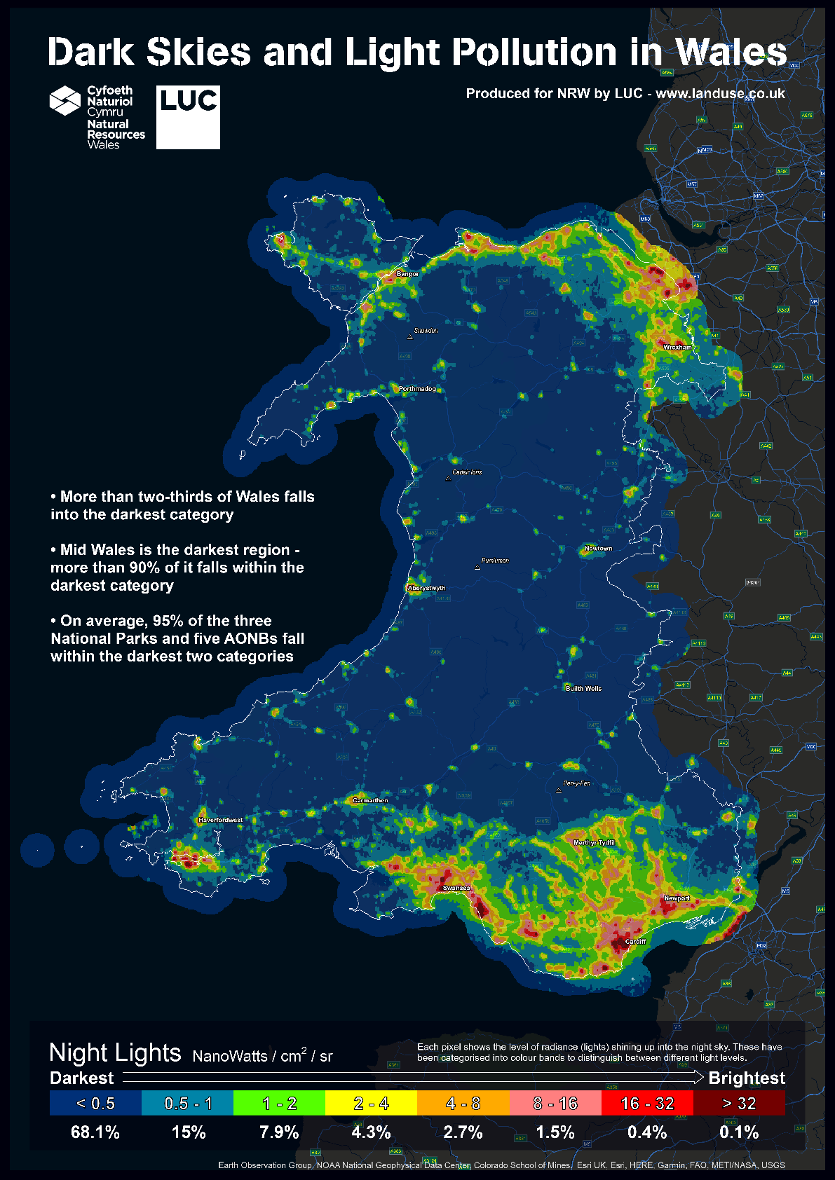
Dark skies and light pollution in Wales poster
A poster showing dark skies and light pollution in Wales has been created which shows the overall proportion of Wales that falls into each colour band, as well as some of the key findings from this study. This poster is available to download from the interactive web app.
Figure 16 Dark skies and light pollution in Wales poster