
Space should be reclaimed from the car park for additional green space and include trees, raised planters, cycle parking, electric bicycle charging stations and electric bike hire. The re-designed space should incorporate specimen tree planting, estuarial planting, seating areas, heritage interpretation, natural play equipment, areas of relaxed meadow management and enhanced wayfinding with the Brunel Trail. Trees should be planted around the edge of the green space to provide areas of shade. Plug plants, including the Tenby daffodil, should be planted under the canopy of trees to create additional food sources for pollinators.
Neyland
×![]()
A Portrait of Neyland's Green Infrastructure
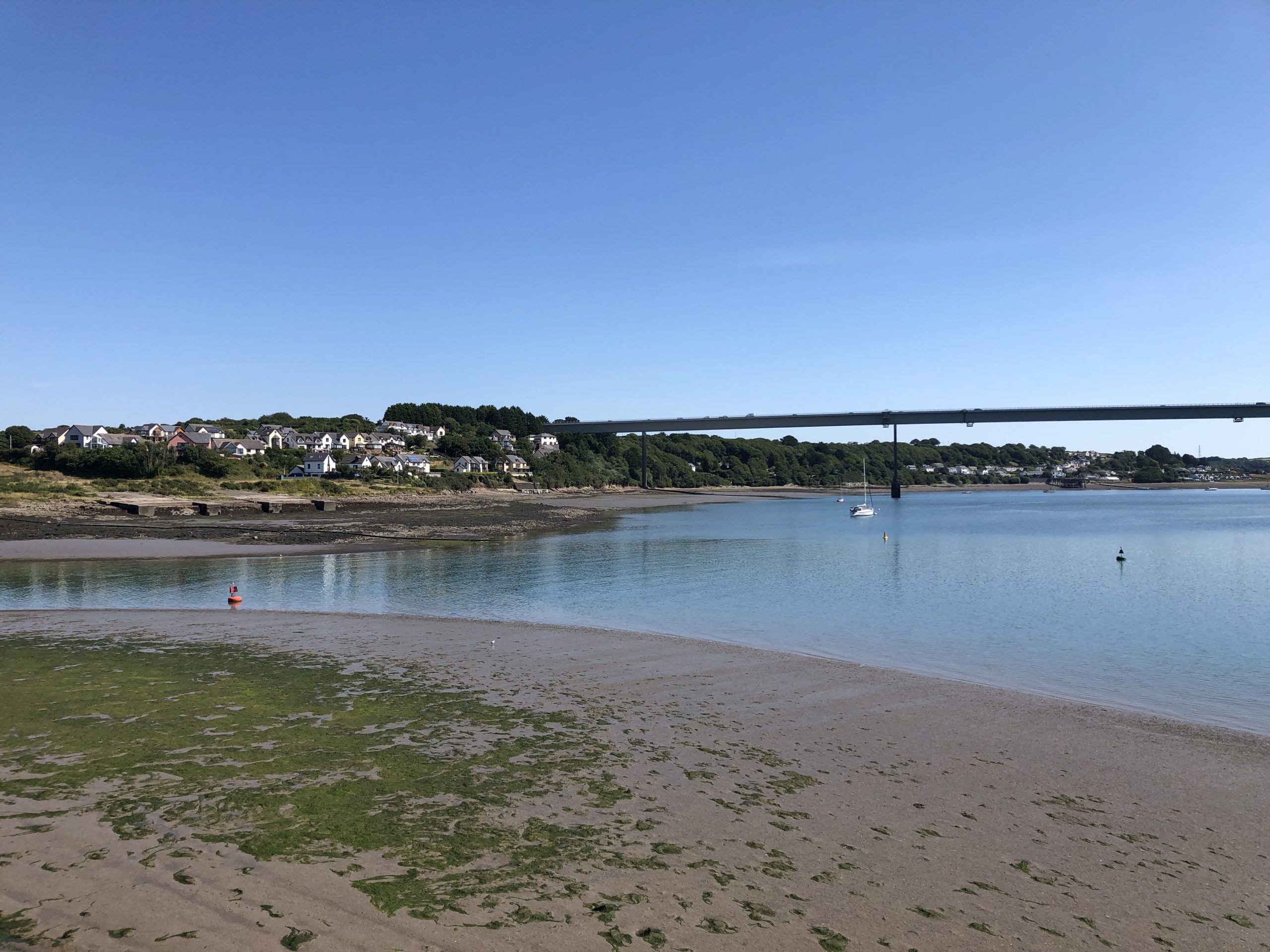
The compact town of Neyland lies at the eastern end of Milford Haven, near the mouth of the River Cleddau. The town is surrounded by hedgerow-bound agricultural fields to the north and west, however, it retains somewhat of an industrial character as historically it was an important shipping and rail terminus. The Neyland Conservation Area is contained along the southern edge and within central portions of the town, with many listed buildings related to the now defunct rail infrastructure. Regular, linear street patterns are common across the southern extents of the town, reflecting the sloping topography as the land meets the coast. From here, views are available along streets and from properties across the estuary and towards the port at Pembroke Dock located on the southern shore Within the north of the town, the street pattern is characterised by a looser suburban form.
Neyland is sited in proximity to two important waterways, the Milford Haven estuary along the southern edge of town, and Westfield Pill, which forms the eastern town boundary. The Milford Haven estuary is part of the Pembrokeshire Marine Special Area of Conservation (SAC), as well as the Milford Haven Waterway Site of Special Scientific Interest (SSSI), whose designated extent, continues north, along the stream corridor of Westfield Pill.
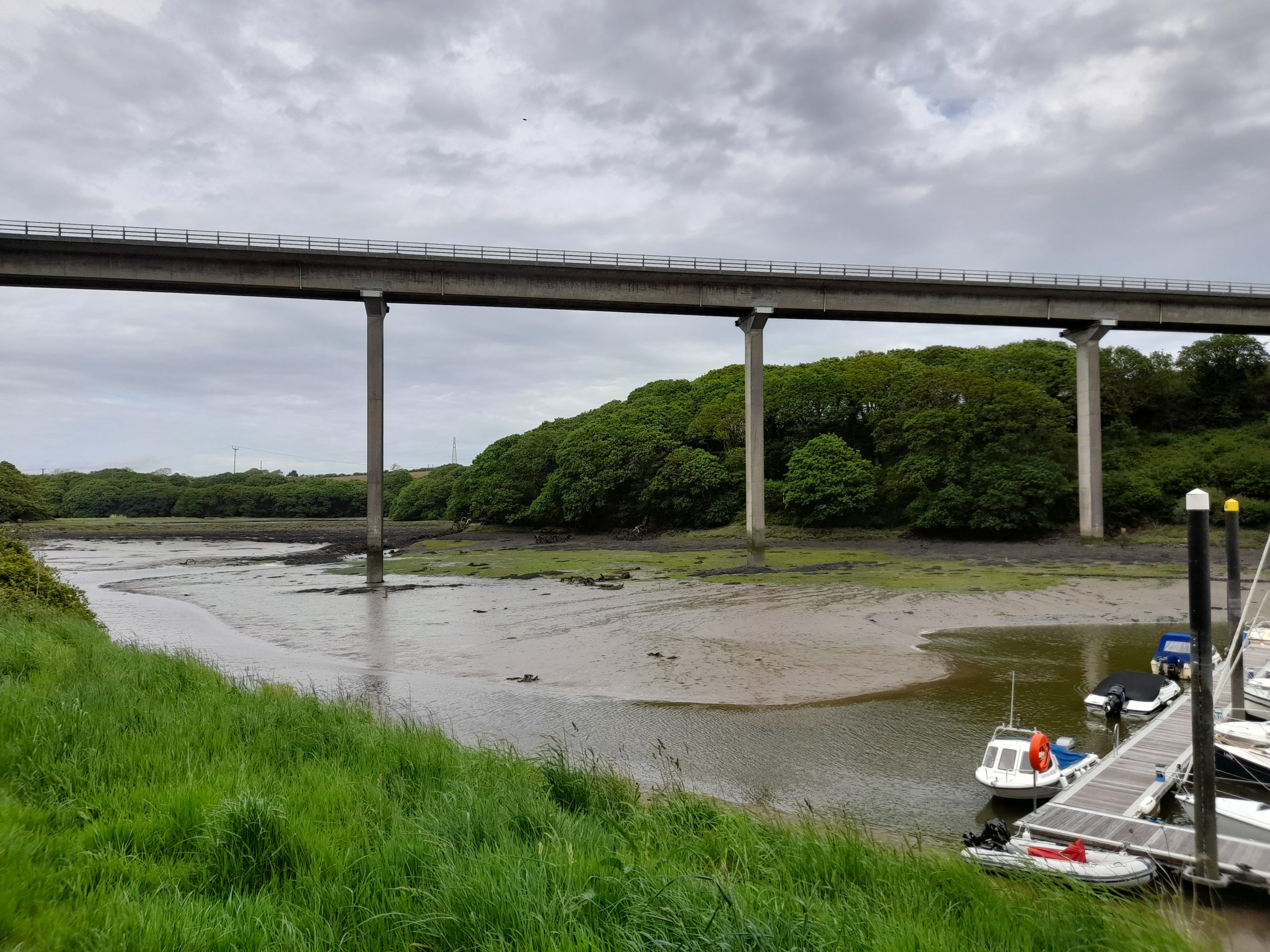
Open spaces within Neyland are small and limited in number, with recreational fields associated with the school and athletic grounds at the northern end of the town and a small recreation space at Harbour Close Park. The Pembrokeshire Coast Path, a promoted National Trail, skirts along the town’s southern edge before continuing along the Milford Haven estuary to the east and west. A stream corridor defines the western boundary of the town at Neyland Vale. This wooded valley, acts as an important wildlife corridor connecting the wider countryside with the Milford Haven and its associated wildlife designations. Westfield Pill marks the eastern boundary of the town and contains Neyland Yacht Haven, a marina for pleasure boats. The banks of the pill also host a section of the Pembrokeshire Coast Path as well as the start of the off-road Brunel Trail cycle link which connects Neyland with Haverfordwest to the north. Along with areas of dense ancient woodland, Westfield Pill also contains the Westfield Pill Nature Reserve which is known to host otters, bats and a rich variety of invertebrates, reptiles, amphibians and birds.
Few Public Rights of Way (PRoW) connect the north of the settlement with the wider landscape with most of the town’s network concentrated along the waterways and to the west of the town within the largely pastoral landscape. However, there are cycle routes which branch off the Pembrokeshire Coast Path and extend east and west along the A477 to offer wider connectivity.
GI Opportunities within Neyland - Download image
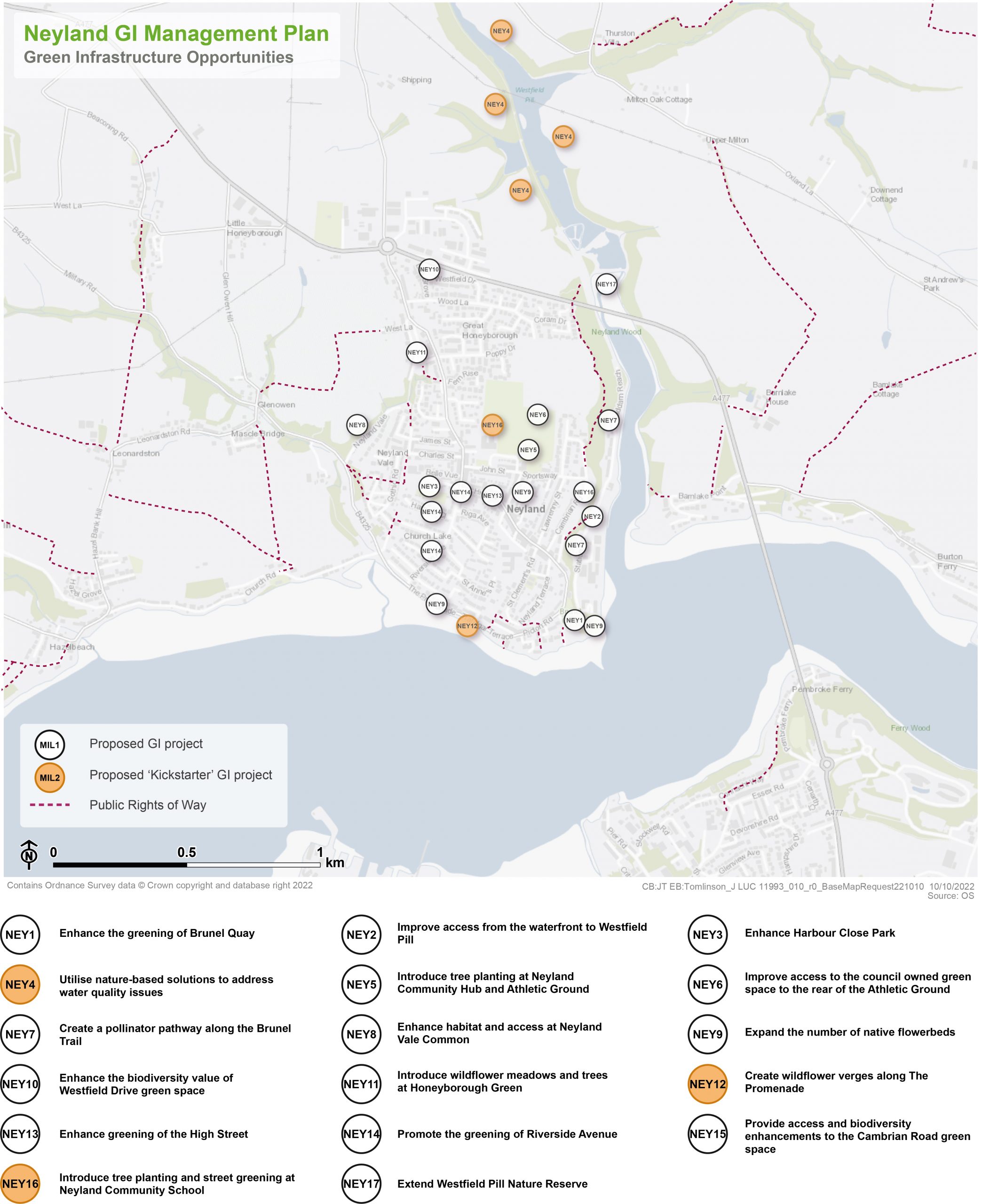
×![]()
GI Opportunities within Neyland
Kickstarter Projects
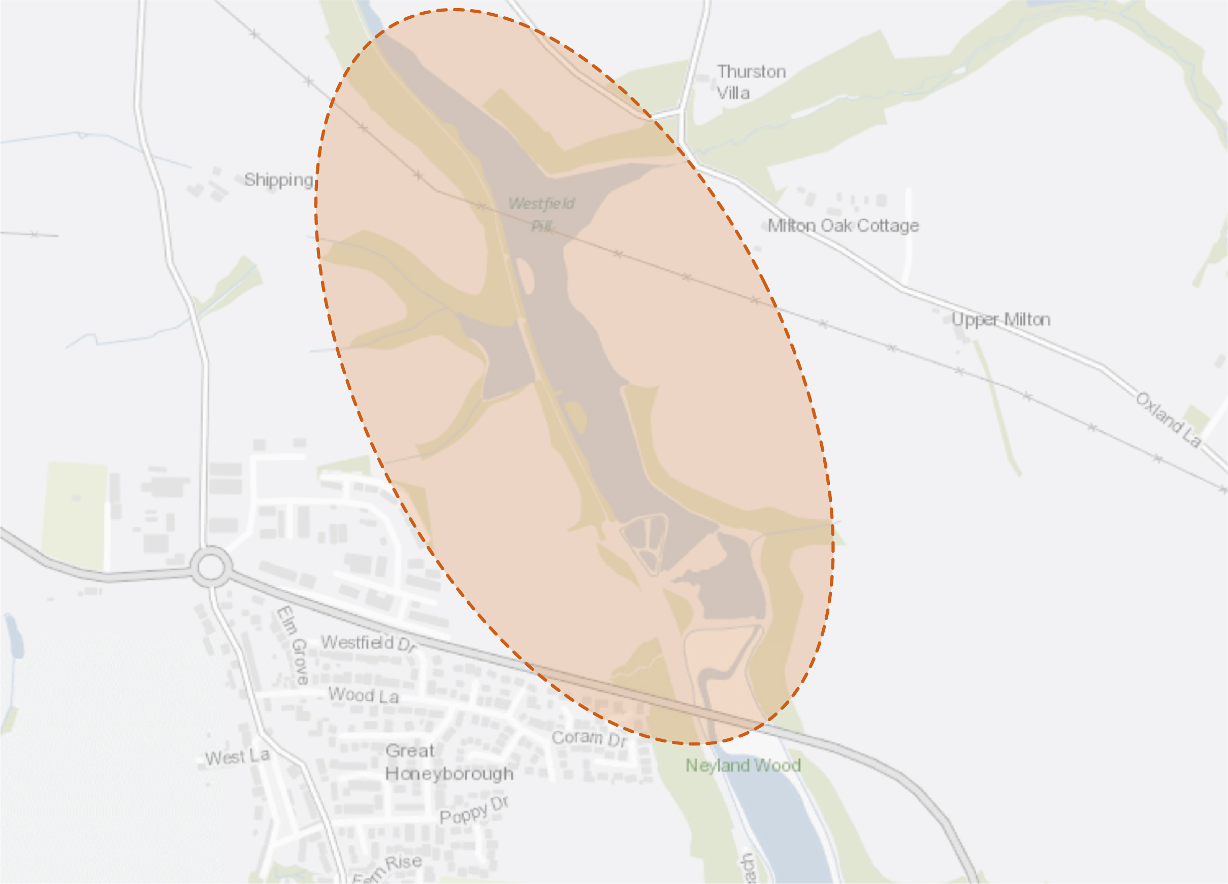
NEY4 – Utilise nature-based solutions to address water quality issues
East of the settlement of Neyland lies the Westfield Pill Nature Reserve, which is of national importance for the assemblage of overwintering wildfowl and invertebrates. The site provides a range of important habitats, both within the lake and on the surrounding land. It also drains into Milford Haven, which is designated as a Special Area of Conservation (SAC). The adjacent farmland is characterised by a series of steep slopes, and previous projects have identified the opportunity to implement changes to land management that would benefit water quality, reduce flood risk and decrease the risk of siltation. The entire catchment of Westfield Pill should be targeted for interventions, with a particular initial focus on the Pembrokeshire County Council (PCC) owned farm lying east of Neyland.
A process of opportunity mapping using remote-sensing data has already been undertaken, identifying areas where changes in land management could deliver benefits. An initial data-gathering stage across the catchment of Westfield Pill would provide local-scale ground-truthing of these opportunities. This data-gathering and opportunity mapping stage could then swiftly be carried through to delivery of a range of land-use change and interventions, which may include;
- Creating riparian buffer strips, reducing grazing in proximity to watercourses;
- Formalising areas of livestock watering, so enabling the erection of fences along watercourse to protect them from bank erosion, bank poaching and manure impact;
- Planting of field margins and shelter belts with trees / shrubs to increase water retention; and
Creating natural dams within small watercourses, slowing flow and increasing diversity of habitats within the landscape.
×![]()
Benefits of the project

×![]()
Delivery of nature-based solutions and ecosystem services
Land use management since the Second Word War has involved increased drainage of the land, in a drive to maximise the efficiency of farmland. This has led to the reduction in the diversity of habitats, the loss of wetlands, wet-grassland and associated wet terrestrial habitats. It has also increased flood risk, as it increases the speed and volume of water flow down catchments, reducing the buffering effect of the landscape during heavy and prolonged rainfall events. Increased drainage of wet soils also has a detrimental effect on the ability of that soil to sequester carbon.
Through the use of techniques such as riparian buffer strips, planting of shelter belts and field margins, the ability of the landscape to absorb and buffer rainfall and surface runoff would be significantly increased. This would have a concomitant beneficial impact on flood risk, water quality and carbon sequestration, as re-wetting of wetland soils would increase their capacity to absorb and lock-in carbon.
Delivery mechanisms
Initially, it is proposed that the project could be targeted on a local, site-specific level by undertaking a survey to ground-truth the presence and scale of opportunity areas that have been identified to date using remote-sensing techniques. This survey could be undertaken by suitably trained citizen scientists, Pembrokeshire County Council (PCC) staff or by an external specialist consultant. Once areas of key opportunity have been ground-truthed and defined, it would be necessary to engage with landowners and land occupiers / graziers in order to present these opportunities and discuss their impacts on current land-use. This may lead to the loss of some opportunities for reasons of commercial and physical agricultural constraints.
The proposed physical interventions and amendments to land management should be delivered by the landowners themselves, or by external agricultural contractors.
Potential partners
- Wildlife Trust of South and West Wales;
- Natural Resources Wales (NRW);
- West Wales Rivers Trust; and
- Pembrokeshire Coastal Forum.
Outline cost
Low cost = <£250k
It is envisaged that this project may cost tens of thousands or less, dependent upon the area of catchment targeted for interventions. Costs would comprise some limited specialist advice / land agent fees, fencing and tree planting costs and possible costs associated with the installation of alternative livestock watering apparatus.
Potential funding opportunities
- Emerging Welsh Government Sustainable Farming Scheme; and
- National Forest for Wales – The Woodland Investment Grant (National Lottery Heritage Fund – Round 1).
Timescale
Quick win = <1 year
Physical interventions could be delivered within a single year. A key unknown for the project would be the time taken to gain landowner / occupier / grazier agreements / consents.
Potential constraints
A key constraint for the project would be landowner / occupier / grazier agreements, as there may be a perceived risk to farm viability associated with some loss of land to riparian margins / shelter belts / field margin planting etc. There may also be resistance to alteration of watercourses with respect to land drainage concerns. These concerns should be countered with the availability of agricultural payments for environmental goods and services, and hence the delayed launch of the Welsh Government’s Sustainable Farming Scheme is a potential constraint in this regard.
Maintenance and stewardship
Maintenance of the softworks and wetland would be required as part of the 60 month establishment phase, including the replacement of failed trees.
Monitoring for success
Subject to the availability of funding, monitoring of the success of the project should be undertaken through simple citizen science, with suitable support. Techniques could include the monitoring of water quality using simple hand-held equipment, or the installation of a simple stream-gauge to monitor streamflow, for example.
Next steps
Secure limited funding (£1k to £10k) to ground truth remote sensing across the catchment, creating a priority list of areas for intervention.
Engage with landowners / occupiers / graziers and enter into agreements to deliver interventions on their land.
×![]()
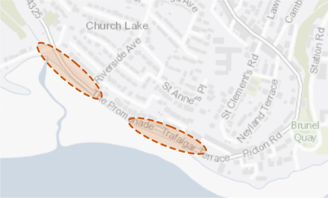
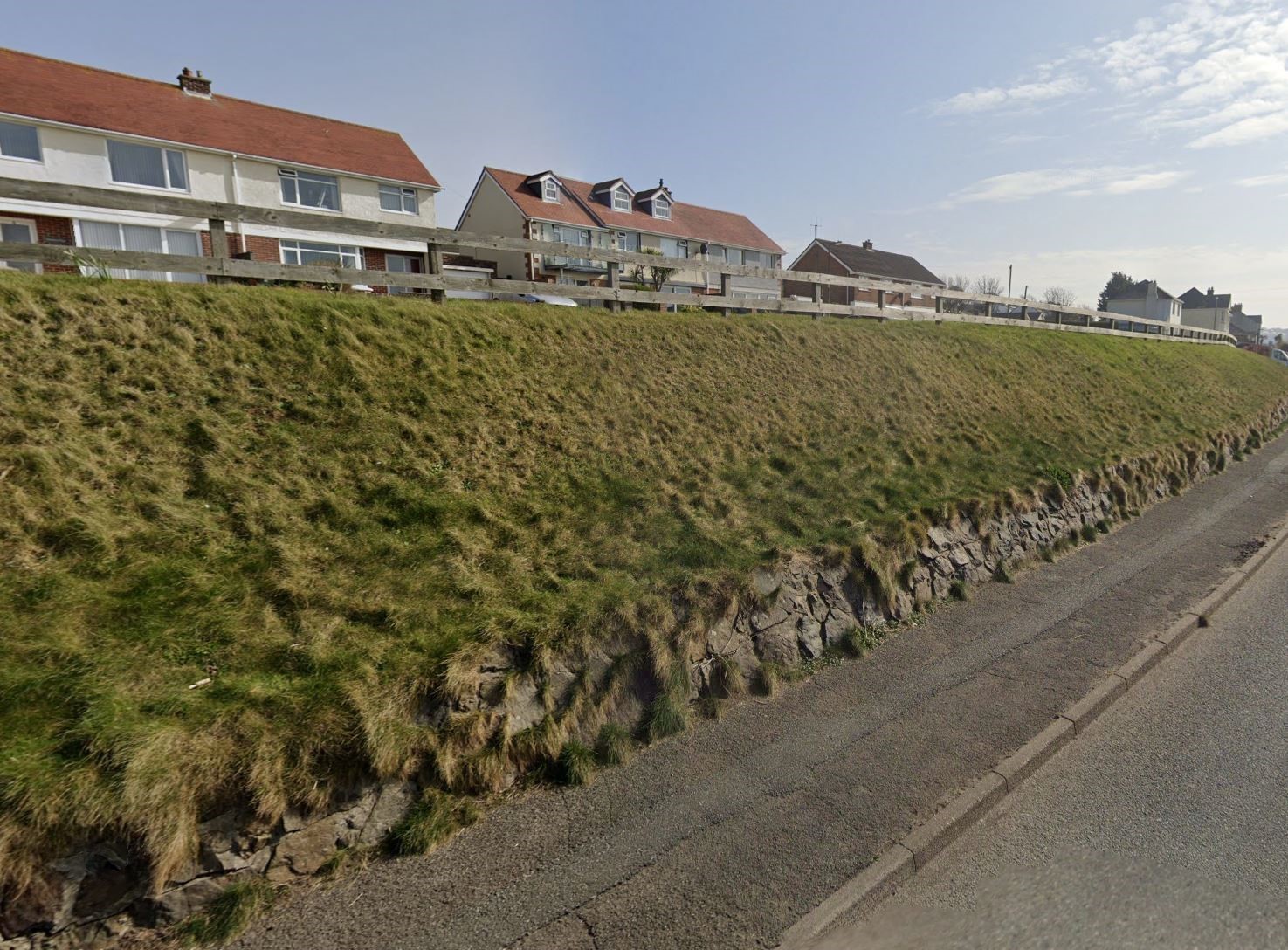
NEY12 – Create wildflower verges along The Promenade
The gradient of the grassed bank bordering The Promenade is too steep to provide a recreational function, including land lying between Church Lakes and Riverside Avenue. Relaxation of the existing mowing regime would encourage a longer and more diverse sward that would provide habitat for a variety of species, namely pollinators. To increase species diversity, native wildflower seed should be sown, or wildflower turf laid. Consideration should also be given to the use of salt-tolerant wildflower species due to the proximity to the coast. The inclusion of yellow rattle within the species mix would help control the establishment of vigorous grasses. In the spring and summer, the establishment of wildflower meadows would also enhance the appearance of the town for those leaving or entering via the B4325.
Signage plays an important role in communicating to the public the benefits of wildflower meadow establishment. This can help overcome perceptions of ‘messiness’ by raising awareness regarding the importance of pollinators.
On the lower slopes, additional small-scale tree planting would be appropriate. However, views across Milford Haven should be retained.
×![]()
Benefits of the project

×![]()
Delivery mechanisms
Annual cuts of wildflower meadows should be integrated into the work programme of the Pembrokeshire County Council (PCC) StreetCare / Amenity Maintenance Team.
Wildflower meadows and the community orchard should be delivered in accordance with the delivery section of the Pollinator Strategy.
There may be a requirement to reduce soil fertility to promote the successful establishment of wildflower meadows. This could be achieved by stripping away the top 5-10 cm of soil in the area where the wet meadow would be created. Autumn is the optimum time to sow wildflower seeds to provide the earliest display of wildflowers the following year. However, wildflower seeds can be planted throughout the year and would begin to bloom after approximately 60-80 days.
Potential partners
- PCC StreetCare / Amenity Maintenance Team;
- Tree Wardens Pembrokeshire;
- Neyland Town Council;
- Pembrokeshire Nature Partnership; and
- Pembrokeshire Meadows Group.
Outline cost
Low cost = <£250k
As described in the delivery section of the Pollinator Strategy, wildflower meadows can in fact save money from reduced mowing. Investment in a cut and collect machine may also aid overall savings on labour costs from gathering cuttings. Cost of wildflower seed is likely to be low, although this figure would be higher if plug plants or wildflower turf are utilised instead.
Potential funding opportunities
- Local Places for Nature Fund; and
- National Lottery Community Fund.
Timescale
Quick win = <1 year
Depending on soil fertility and if wildflowers are sown after Autumn, it may be the case that the seeds do not bloom until after their first winter season.
Potential constraints
Consideration should be given to how to gather the cuttings and remove them from the wildflower meadow to prevent enrichment of the soil. The most efficient way to do so is with a cut and collect mower but this requires capital investment. Otherwise, arisings should first be gathered into rows which are then gathered into individual stacks. This can be labour intensive.
There can be a perception that wildflower meadows are untidy or messy, especially before and after flowers have bloomed. This could result in complaints from the public. Signage to communicate the benefits of growing wildflower meadows can help increase understanding and education regarding the importance of pollinators.
Maintenance and stewardship
A wildflower meadow requires a cut and lift at the end of the season. This is typically in September. The arisings should ideally be left for seven days to shed seed before removing. A second cut and lift may be required in early spring to remove winter growth. Care is required when mowing as small mammals, amphibians and reptiles may be hiding in the grass. Some birds nest in larger meadows, so mowing should not be undertaken until after the beginning of August. Dominant species such as nettle and dock should be managed through selective scything or hoeing.
Use of fertilisers, pesticides and insecticides should be avoided.
Monitoring for success
Monitoring should align with national schemes. The UK Pollinator Monitoring Scheme runs Flower-Insect Timed Counts (FIT Counts). This involves counting the insects visiting one of the 14 flower species target flowers within a 50cm by 50cm square patch for 10 minutes. Local residents and schools could be encouraged to participate in this as a citizen science initiative. Alternatively, plant ‘indicator species’ can be recorded within a 1km square to monitor species diversity.
Next steps
Review the delivery section of the Pollinator Strategy to determine the process and review case studies relating to the creation of wildflower meadows. Engage with the PCC StreetCare / Amenity Maintenance Team to communicate the proposed mowing regime.
×![]()
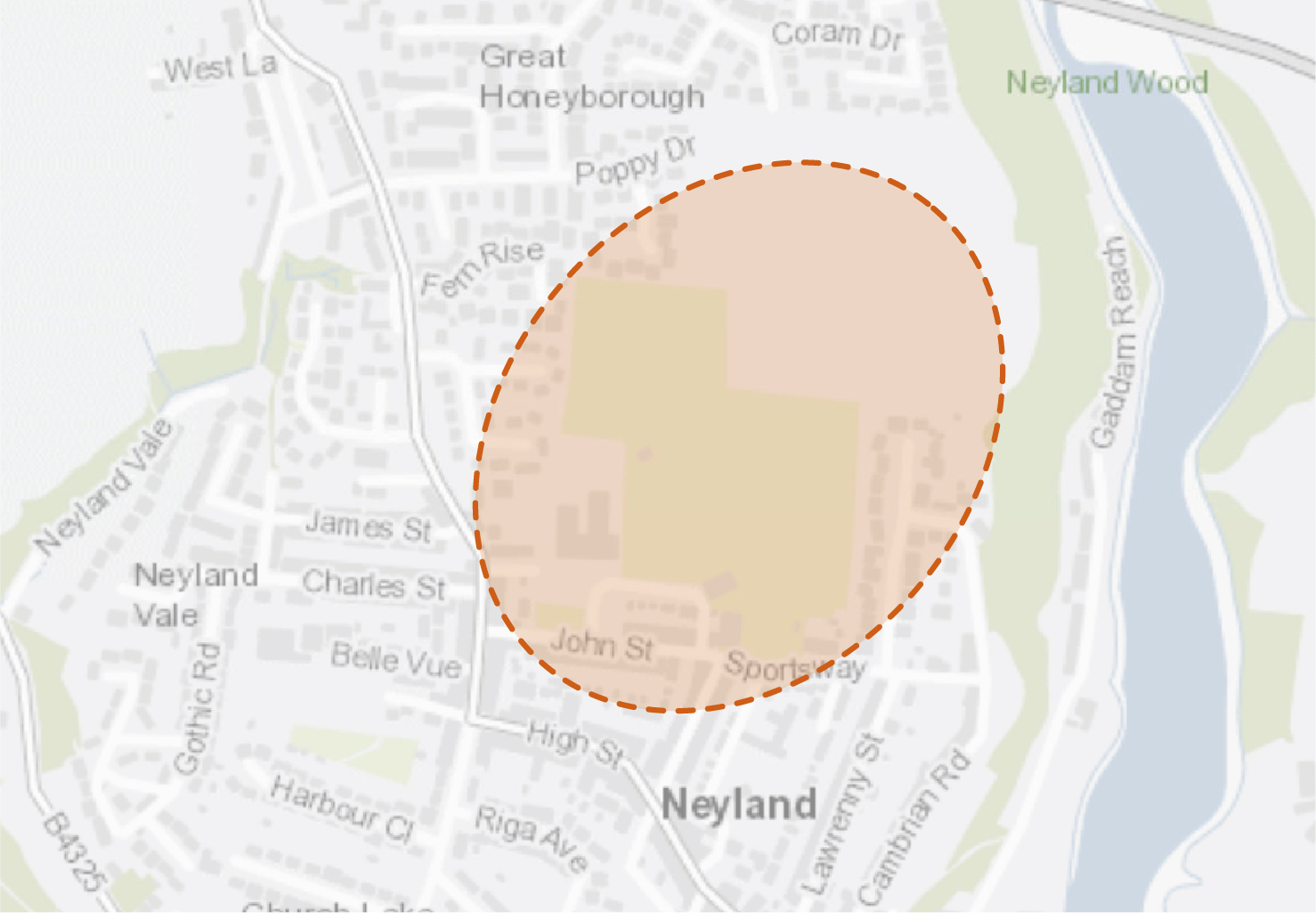
NEY16 – Introduce tree planting and street greening at Neyland Community School
Neyland Community School and Neyland Community Hub / Athletic Ground are located broadly centrally within the settlement and form the largest areas of greenspace within the urban context. Neyland has a notably lower percentage canopy cover when compared to other settlements in Pembrokeshire, at around 9.7%. Tree planting opportunities, particularly around field margins, would provide flood alleviation benefits and help create a wildlife corridor connecting the site to the ancient woodlands located to the east. The intervention would also aim to deliver wider connections to Westfield Pill Nature Reserve, enhancing ecological diversity.
The project provides the opportunity for a range of educational benefits that could be linked to the curriculum and provide practical opportunities for student engagement. Tree planting could also potentially include the development of a wider Forest School concept with the intention of developing connections with the natural world.
×![]()
Benefits of the project
×![]()
Delivery mechanisms
Neyland Community School should be supported to deliver and lead the project, possibly in collaboration with Neyland Town Council. If possible, it may be beneficial to engage a Forest School professional to support the delivery of school sessions and help maximise impact with regard to wider environmental education.
An annual planting programme should be established to successfully plan, deliver and manage the new tree planting over the 60 month establishment period. Sufficient planning is required prior to the bare-root planting season (October-March at the latest) to ensure ground checks / soil testing is completed.
Trees should be delivered in accordance with the delivery section of the Urban Tree Planting Strategy.
Potential partners
- Neyland Community School;
- Neyland Town Council;
- Neyland Community Hub;
- Local community;
- Pembrokeshire County Council (PCC) StreetCare / Amenity Maintenance Team; and
- Tree Wardens Pembrokeshire.
Outline cost
Low cost = <£250k
The cost would likely be low but dependent on capacity within the school to manage the project. Opportunities should be sought to identify ‘free tree giveaways’ to schools which often run between November and March (e.g. Woodland Trust and Tree Council).
Potential funding opportunities
- Woodland Trust (‘free tree giveaways’);
- PCC;
- National Lottery Community Fund;
- Local Places for Nature Fund; and
- The Tree Council.
Timescale
Quick win = <1 year
To provide an opportunity to engage the maximum number of students, it would likely be beneficial to extend planting works over several seasons. Some initial planting could be undertaken within the first year.
Medium-term = 1-5 years
Tree planting, maintenance and monitoring would need to extend over the 60 month establishment period.
Potential constraints
Planting locations would need to consider the existing function of the site, including sports and playing field use.
Safety, security and the maintenance of sight lines into and out of the site would also need to be considered.
Maintenance and stewardship
Establishment and maintenance should be informed by the delivery section of the Urban Tree Planting Strategy. Ongoing maintenance should incorporate input from students, providing practical involvement with ongoing learning opportunities. Engagement with community groups or a contractor may be required to ensure watering continues throughout school holidays, especially during summer months for the 60 month establishment period.
Monitoring for success
Measures for success would include the quantity of trees planted and the number of students and community groups engaged.
The establishment of a new or enhanced Forest School offer could form a long term aspiration.
Next steps
Initial engagement with Neyland Community School should involve the development of a project plan, outline programme and opportunities to link with the curriculum. A project lead within the school who is able to oversee the practical work should also be identified.
Consideration should be given to the most appropriate species mix, informed by the delivery section of the Urban Tree Planting Strategy. The selection of native species would likely be a priority in order to strengthen and improve ecological connectivity to existing woodland tracts.
Project Long List
Following the alignment of the former railway tracks, the access through the quayside industrial units should be clarified, surface markings provided and interpretation introduced to direct people through the space. Forming a section of the wider Brunel Trail, the opportunity exists to create a coherent route from Brunel Quay. Additional access routes along Station Road could also be explored. Modifications to the mowing regime and the sowing of wildflower meadow should be implemented along this route to provide enhanced aesthetic and biodiversity value.
Enhance wayfinding and entrances to Harbour Close Park from Victoria Close, Belle Vue Street and Church Way by opening up sightlines and removing unwelcoming boundary treatments. Enhance play provision within the site by providing natural play trails and education boards coupled with habitat enhancements and insect hotels. Consideration should also be given to how seating areas cater for teenage girls, an often forgotten demographic. Hedgerows, edible hedges and wildflowers should be introduced along the park’s boundary.
Refer to Kickstarter Projects.
Consider re-planting the four raised planters at the entrance to the Neyland Community Hub. These should be planted with native trees and complemented with further tree planting within the grass verge to the rear. Additional tree planting should also be introduced along the boundaries of the sports pitches to expand and enhance the existing hedgerow network.
Currently, access to the Pembrokeshire County Council (PCC) owned land to the rear of the Athletics Ground is restricted. Consideration should be given to enhancing the access and signage from the Neyland Community Hub and from the existing LOCAL Development Plan (LDP) allocation to the north to provide valuable recreational space for surrounding communities. The introduction of fruit trees and the relaxation of the mowing regime would provide additional enhancements for biodiversity. The scheme should include reference to the proposed shared-user path connecting Poppy Drive with Sportsway.
Plug plants should be introduced along the verges of this route linking Neyland to Haverfordwest, ensuring a mowing strip is maintained parallel the path edge. In wider open areas, wildflower meadows should be created. Fruit trees should also be planted along the route to create an edible corridor. Invasive species should be removed and eradicated where present. Proposals should complement existing plans to remove barriers as a mechanism to improve access for all.
Glades and rides should be created in the woodland to encourage a diverse ground flora. Create an access route for exploration through the woodland. Wayfinding should be introduced to connect new residential development at Victoria Close with Neyland Vale. Vegetation around the perimeter of the pond is overgrown and detracts from the pond’s value for biodiversity. As a consequence, mature trees and scrub should be cut back to increase light and encourage marginal aquatic vegetation to flourish. Invasive buddleia and Japanese knotweed should also be removed.
Plant pollinator friendly flower beds, borders and pots in sheltered sunny spots to provide food from early spring to winter. Planting blocks of the same type of flower saves time for pollinators as they can move from flower to flower more quickly. Use of harmful chemicals should be avoided. Suitable locations may be the seating areas by Windsor Gardens, The Promenade and at Brunel Quay. This would provide additional connectivity to the sleeper flower beds on Neyland Terrace and Railway Terrace.
Extend the hedgerow planting bordering the A477 and shared-user path with scrub and native tree planting to provide additional structural complexity, shelter, food, and nesting sites. Wildflower strips should also be introduced around the edges to provide nectar for pollinators.
Honeyborough Green is designated common land and could be enhanced further through additional tree planting. Provision should be made for future tree succession, including planning for replacements due to ash dieback (Hymenoscyphus fraxineus). These interventions would provide additional areas of cooling and shading in the summer months. Areas of the green could also be planted with wildflowers to provide connected pollinator habitats and enhance the appearance of the greenspace. Proposals should complement wider shared-user path proposals connecting the A477 with Neyland.
Refer to Kickstarter Projects.
Introduce street trees at key nodes or through the reconfiguration of existing parking spaces along the High Street. Proposals should be developed in conjunction with wider proposals to implement a shared-user path along the High Street. Local businesses and residents should also be encouraged to install window boxes with pollinator-friendly flowing plants where possible.
The opportunity exists to incorporate tree planting within the existing central reservation on Riverside Avenue (services permitting). Native species should be selected where possible. Trees should also be planted and the mowing regime relaxed at the grass verges at Riverside Avenue and Harbour Close.
Excellent views of the estuary are afforded from Cambrian Road. However, pedestrian access is currently limited and restricted by the steep gradient of the greenspace. Steps and a gently sloping boardwalk could be added in this location to provide access from Neyland Marina to the town centre. The mowing regime of the steep slopes should be relaxed and sown with wildflowers to create and attractive meadow. Additional tree planting could also be considered, whilst ensuring the retention of long range views.
Refer to Kickstarter Projects.
Westfield Pill Nature Reserve lies within Flood Zone 3, located adjacent Westfield Pill watercourse and lake which feed into the Milford Haven Estuary. Extension of this site, particularly along the agricultural eastern margins, would act as floodplain storage providing protection from tidal surges whilst enhancing the ecological diversity of the area.