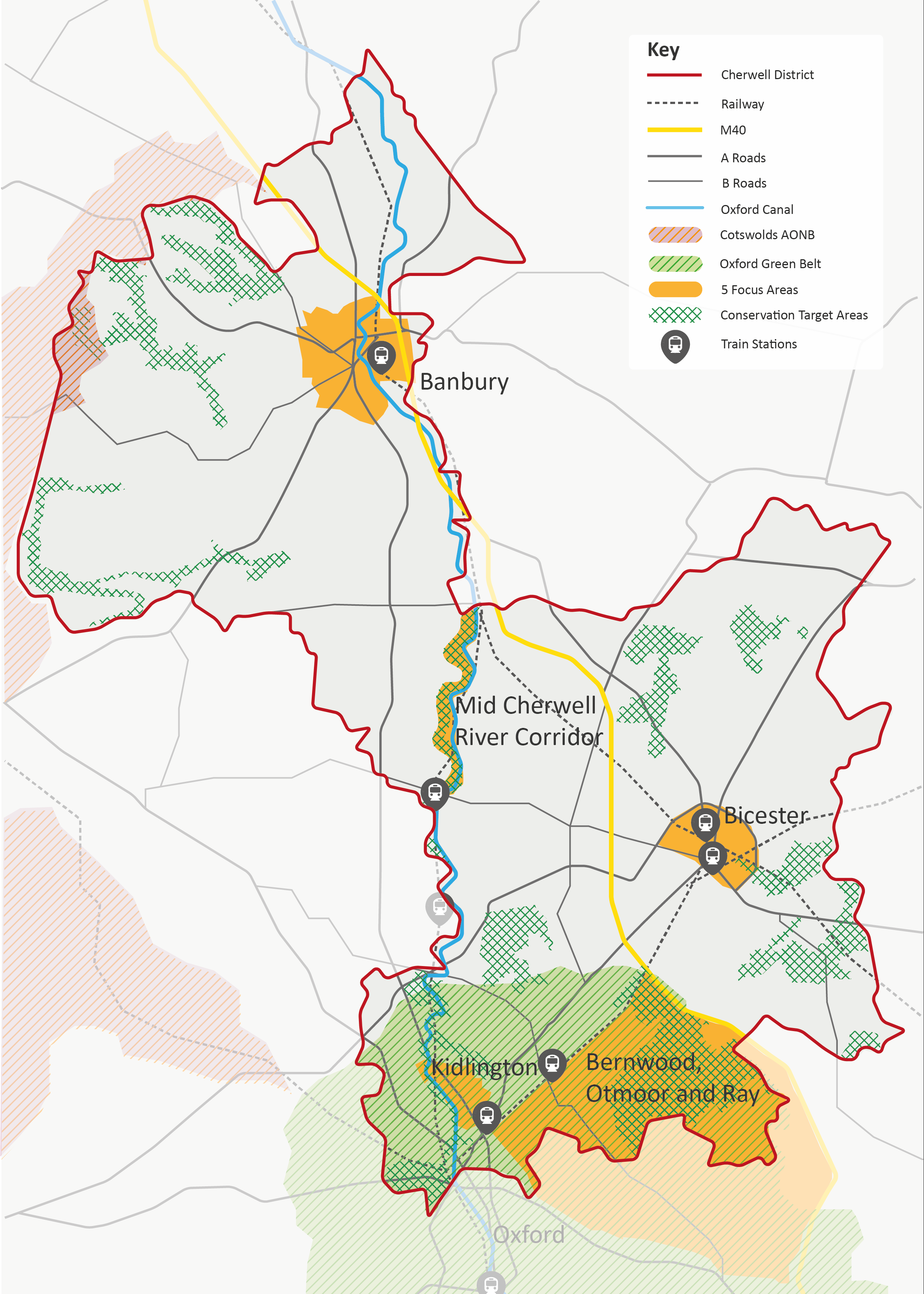
Overview of Focus Areas

In order to most effectively prioritise opportunities across the District, this Strategy has identified five “Focus Areas”.
While the Strategy is strategic in scale and District-wide, these areas allow the Strategy to explore more closely opportunities within areas where either:
- Existing data highlights strategic GBI assets or corridors – providing an opportunity for strategic, linked-up, landscape-scale GBI.
- The area in question is set for major change through future development – and therefore the GBI network requires protection and enhancement.
These Focus Areas were also ‘tested’ at a virtual round table of key stakeholders in May 2022 (see Appendix A).
The following three Focus Areas are highlighted because they are set for major change through future development:
- The wider Banbury urban area.
- The wider Bicester urban area.
- The wider Kidlington urban area.
The remaining two further Focus Areas were identified outside existing urban areas, in areas where there are strategic GBI assets or corridors, as highlighted by existing data sets – notably the Oxfordshire Nature Recovery Network. They are:
- The Otmoor, Bernwood and Ray Area.
- The Mid-Cherwell River Corridor.
These five Focus Areas are covered here in a series of profiles. Each profile highlights key opportunities based on the evidence gathered through the development of this Strategy. Each profile is made up of:
- A brief ‘portrait’ of the Focus Area.
- A summary of the key challenges it faces.
- An indication of relevant local delivery partners for GBI.
- A series of Strategic Projects, setting out:
- The purpose of the project.
- Key components of the project.
- Indicative costs.*
- Indicative time scales.**
- Delivery guidance.
- One of the key drivers for this report was to draw on the significant evidence and data available, interpret it, and use it to identify key GBI interventions needed across the District.
Opportunities were identified and developed by exploring and bringing together the following information sources:
- Existing policy documents.
- Input from key stakeholder consulted during the development of this Strategy.
- Spatial data sets – including the Oxfordshire Natural Capital mapping and the Oxfordshire Nature Recovery Network (see Appendix 1 for further information on data sets and sources used.)
*: With indicative time scales and costings, these are only provided at a strategic level and significant further feasibility work will be required in order to fully cost up each intervention.
**: When considering time scales, readers should also note that there is a difference between the physical build time scales and the time scale for likely outcomes (when we are likely to see the full benefits from the intervention). The time scales here refer to likely time needed for the physical build.