Carmarthen Action Plan
A green-blue portrait of Carmarthen
Image: River Tywi running through Carmarthen
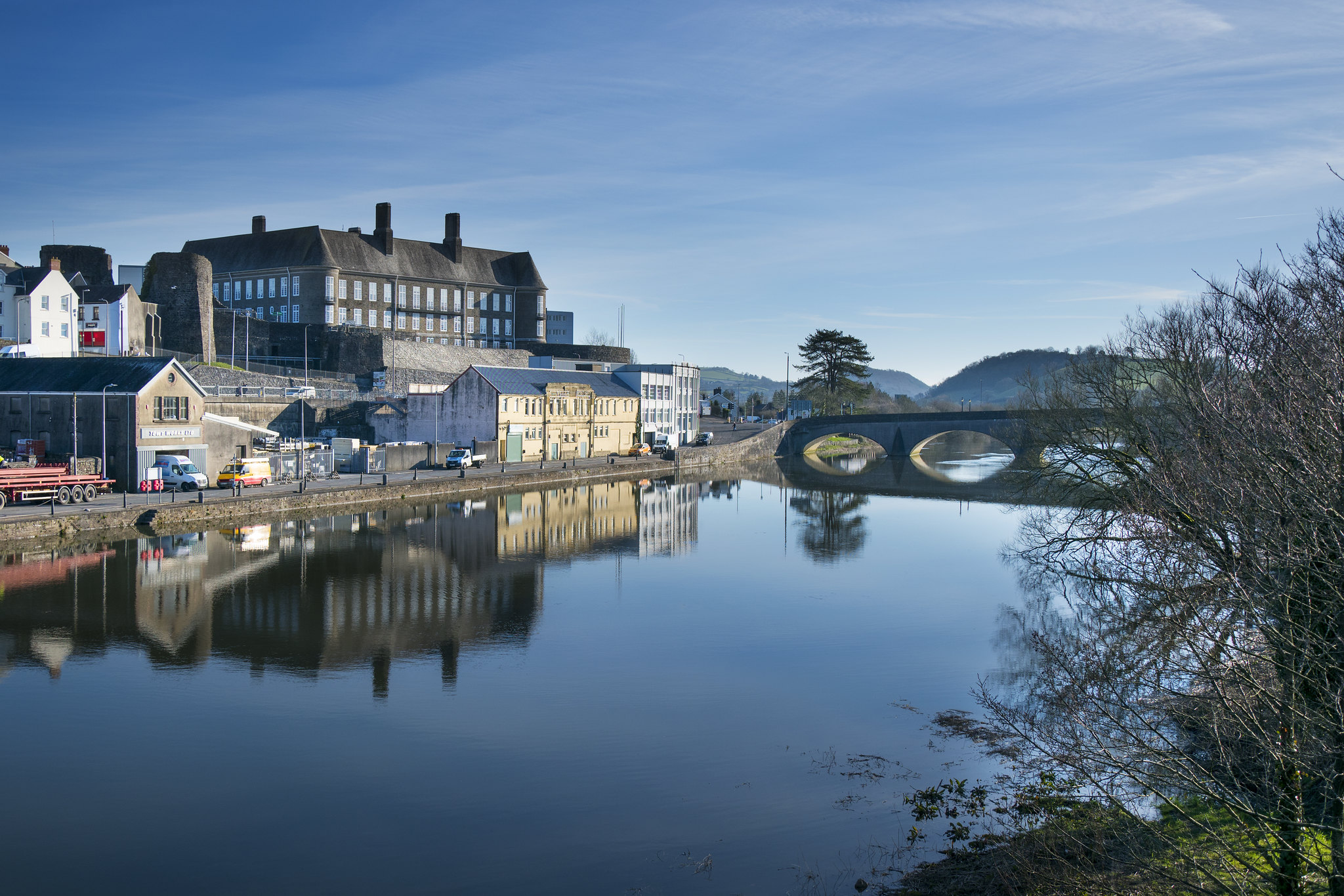
Carmarthen is a historic quayside town located on the River Tywi. It is identified by the Future Wales National Plan as a Regional Growth Area in south west Wales.
The River Tywi dominates the town due to its size. The Tywi is Wales’s longest river and weaves its way from its source in the Cambrian Mountains through Carmarthen into Carmarthen Bay.
Carmarthen’s old town sits on higher ground to the river’s west and newer areas of the town have expanded onto and across the river’s floodplain.
Carmarthen boasts several popular tourist and local attractions. The Wales Coast Path can be reached south of the town to connect to Carmarthen Bay. Carmarthen Castle provides views over the river, down the Tywi Valley.
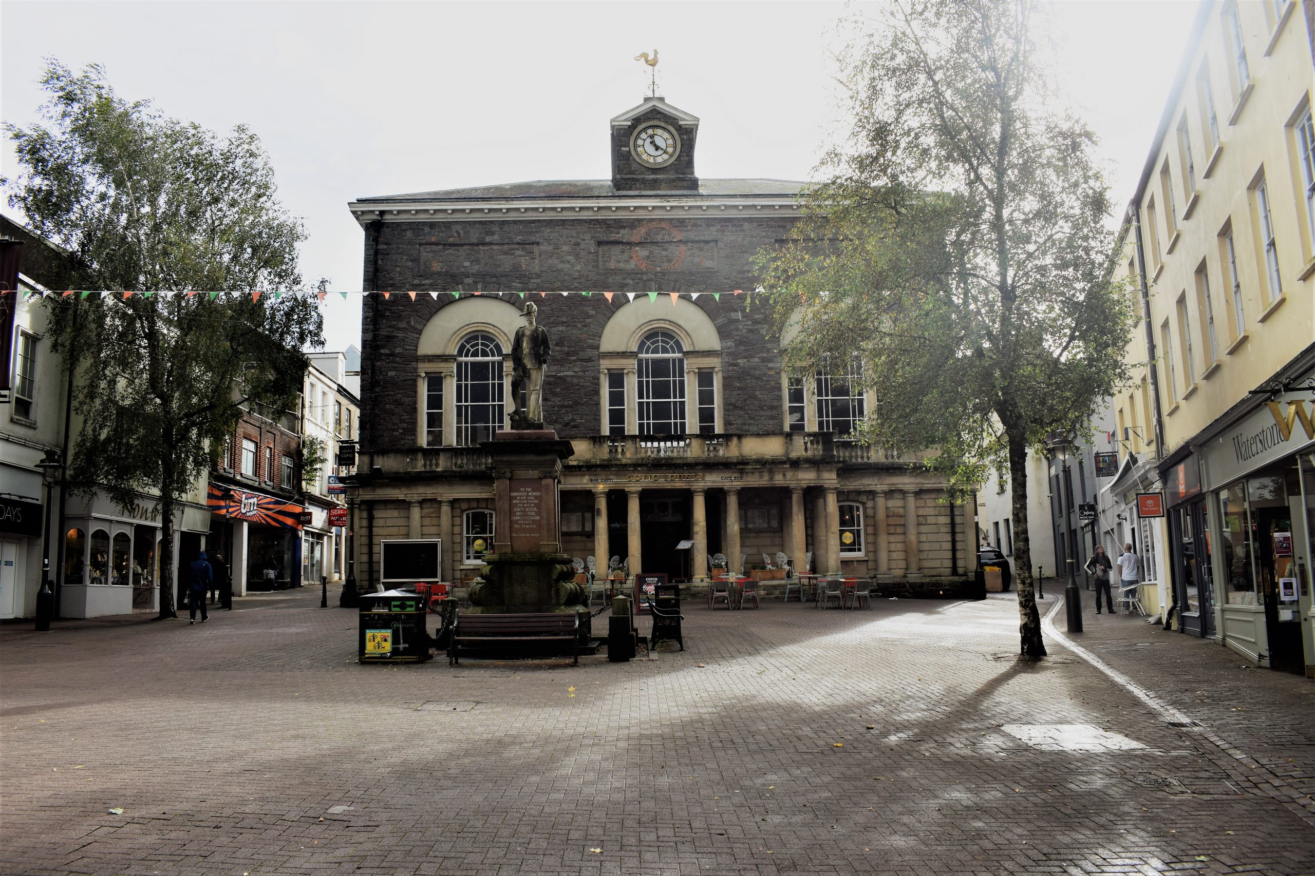
A cluster of heritage assets, vintage and antique shops attract visitors to the town. However, despite Carmarthen’s riverside location and setting, the town lacks a strong connection to its river corridor and lacks both green space and tree cover.
Image: Historic environment around Guildhall Square
“There aren’t many green spaces in the town centre – we need green infrastructure that’s more family friendly and brings back the community spirit”
– Stakeholder, online survey
See Appendix A for a summary of all stakeholder comments.
What are the key challenges facing Carmarthen?
Flooding
Flood defences protect a small area of land between the Tywi and A40 road. However, extensive areas of Carmarthen are still at risk of river flooding. Flood resilience will be a central part of planning for Carmarthen’s future.
Particular areas of impermeable ground cover are concentrated in the older areas of the town centre.
Economy and public realm
Carmarthen is a historic quayside town with distinctive characterful streets, many heritage assets and a strong place identity. The town also benefits from a number of entertainment, cultural and theatre attractions, making it a destination town. However, the town has been hit particularly hard by the Covid-19 pandemic and wider trends, suffering a significant drop in footfall from tourists and town centre workers. As of 2021, the town had a 17% vacancy rate in its retail units.
The public realm of Carmarthen lacks green space and tree cover and cars can dominate. This discourages people from walking and cycling.
Image: Pedestrian and cycle bridge connecting station with town centre
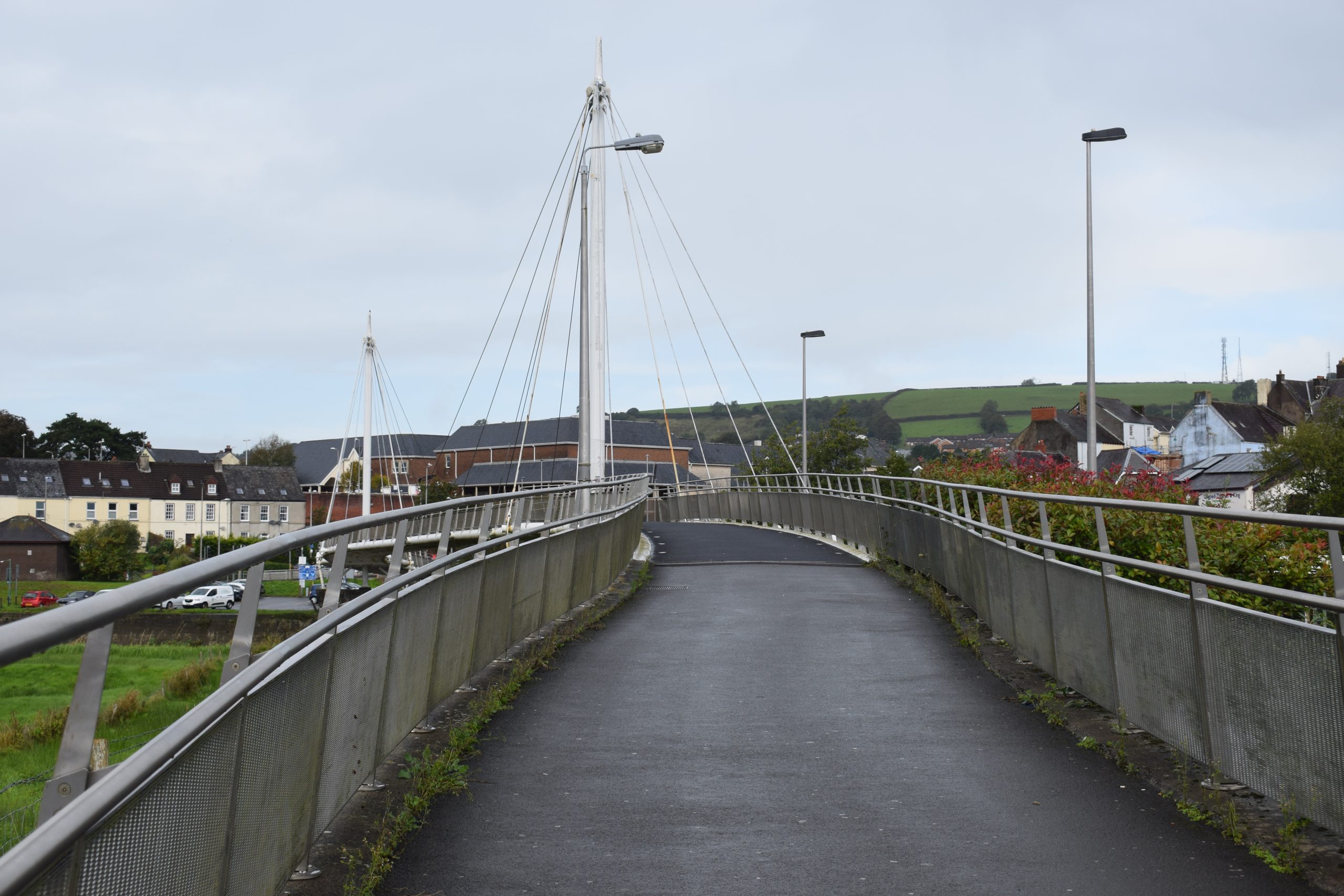
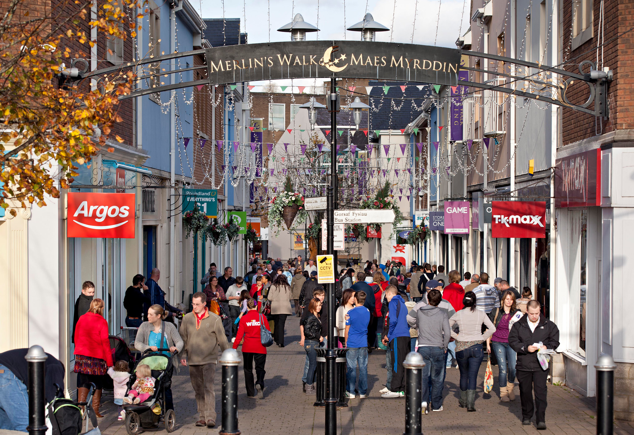
Image: Merlin's Walk Shopping Centre in Carmarthen
Air quality
Nitrogen Dioxide (NO2) pollution, largely caused by road traffic, has had significant negative effects on air quality in Carmarthen. Carmarthen contains one of Carmarthenshire’s Air Quality Management Areas (see interactive map). This is not helped by the low level of tree cover.
Expanding tree planting and green coverage in Llanelli could go some way to addressing this, however reducing car use by making the town more attractive to walkers and cyclists will remain a key priority.
Population
Carmarthen benefits from a vibrant and active local community. As elsewhere, the GBI network will need to respond to the needs of an ageing population.
The social and economic status of Carmarthen residents is below average for Wales for most areas of the town, but particularly so in Carmarthen Town North (see interactive map). GBI interventions should focus in particular on areas of concentrated deprivation, particularly when it comes to access to high quality open space and well-being resources.
Welsh language
Support for the use and promotion of the Welsh language and culture is a key objective of Carmarthen’s Recovery Masterplan. Opportunities to develop Yr Egin as a creative industries hub based around Welsh Language media could boost the role of the Welsh language in the town.
Access to green space
Carmarthenshire’s Open Space Assessment (2020) highlights that the north of the town has almost no provision of natural green space. It also highlights deficits in provision for young people.
Map of Key Opportunities in Carmarthen
Key Opportunities in Carmarthen - Download image
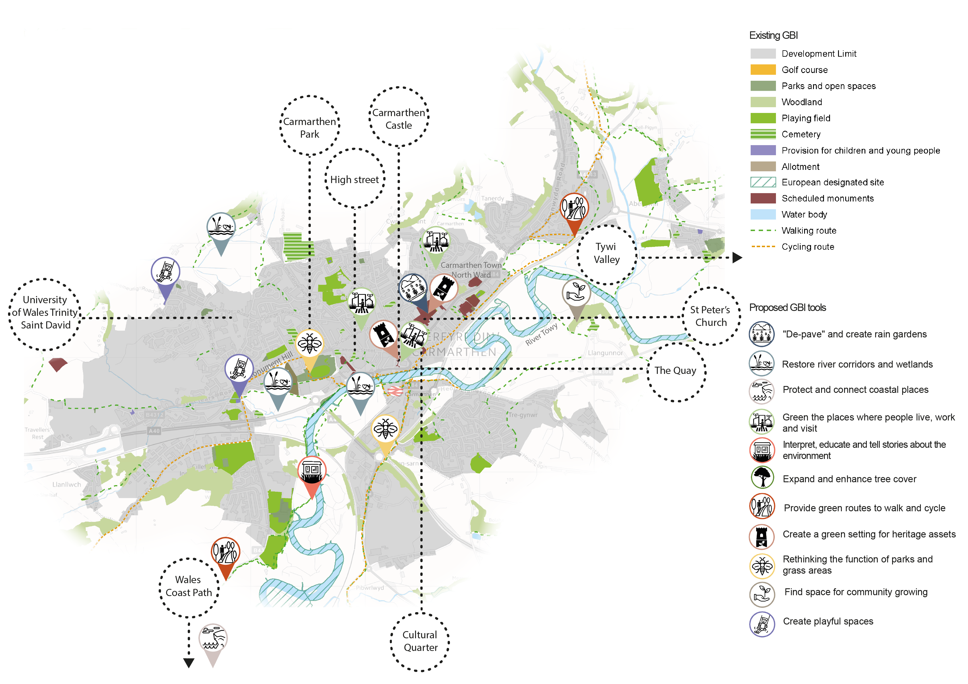
View the full GBI toolbox, learn how to use the toolbox with each town and explore the map of green and blue infrastructure assets in Carmarthenshire in more detail.
Overview of key opportunities for Carmarthen’s GBI network
The paragraphs below provide further commentary on the GBI opportunities highlighted in the map above.

'Depave' and create rain gardens
Residential areas and key roads in newer areas of the town that have expanded onto the floodplain should be prioritised for protection against river and sea flooding. There are opportunities for depaving or increasing permeability at the extensive car parks, paved and heavily built-up areas in the towns. This would reduce the risk of surface water flooding.
Prioritising de-paving in key vulnerable areas and introducing targeted rain gardens in development along the river corridor would improve natural resilience to surface water and river flooding, alongside improvements to habitats and water quality in Carmarthen’s rivers. Data on sewer overflows in Carmarthen highlight that flows are highest in older areas in and around the town centre – these areas would benefit the most from targeted rain garden schemes.
Restore river corridors and wetlands
Natural Resources Wales has identified areas north of Trinity College and along the River Tywi where planting additional floodplain and riparian woodland would aid Natural Flood Management (NFM). Restoring habitats along the town’s key river corridor, the River Tywi, would also help to provide important aquatic habitats.
Other important opportunity areas for riparian planting and wetland management include the wetland site south of Monument Hill, the floodplain grazing marsh on the site west of Carmarthen railway station, the wetland north of Reservoir Road, the Sewage works at Pantan Mawr Farm and the Quay.

Protect and connect coastal places
The Wales Coast Path can be accessed from south of the town. Connecting the town to this coastal route along green walking and cycling routes would strengthen its link to Carmarthen Bay. Nature-based solutions (NBS) to coastal flooding should be prioritised, and this use of natural processes should be effectively communicated to local communities.
Green the places where people live, work and visit
GBI could contribute to a stronger sense of place and distinctiveness by greening of areas north of the town centre including Merlin’s Walk, Jackson’s Lane – as part of the new masterplan – and St Catherine Street, using localised environmental enhancements.
The emerging ‘cultural quarter’ focused on King Street should be another focus for high-quality urban greening, with attractive outdoor space for music and performance. Interventions might include green boundary treatments (streets), pedestrian routes, landscaping, pocket parks and green rooves on bus stops. Traffic calming measures which alter the layout of the street offer opportunities to integrate street trees, more seating, green walls and pocket parks.
Greening of urban residential areas should focus on areas of socio-economic deprivation such as Carmarthen Town North, in order to improve access to quality open space as a well-being resource.

Expand and enhance tree cover
Key corridors which should form the focus for street trees include the walking route between the university and the town, the high street and wards where levels of socio-economic deprivation are higher (see interactive map).
While narrow streets make street trees more challenging, the reconfiguration of some parking spaces could help make space for street trees in the public realm.
Wider woodland planting in the surrounding landscape will help to address wider resilience of the natural environment. Tree planting (or ‘mini forests’) in Carmarthen Park could help shelter the park from the wind, and hedging between Carmarthen Park and Morfa Lane could be used to tackle surrounding poor air quality. Community woodland management, such as Coed Ty Llwyd, should also be supported.

Interpret, educate and tell stories about the environment
Educational and interpretation boards around the town’s rivers and green spaces would help visitors and local people connect to the town’s rivers and green setting – they should highlight bird watching opportunities and provide information on the habitat and species the area supports.
Improving the signage on the river corridor connecting to the Wales Coast Path and Carmarthen Bay would be a key step in promoting Carmarthen’s natural assets to the community.

Provide green routes to walk and cycle
Key destinations which should be linked with high-quality green routes include the Wales Coast Path, the railway station, the University, Yr Egin Media House and Nott Square.
Creating stronger connections between the riverside and the rest of town should also be a key area of focus, opening up the riverside with seating, improved habitats and interpretation boards.
GBI features and linear habitat enhancements should also be planned for the new Tywi Cycle Path to Carmarthen Bay.

Create a green setting for heritage assets
An enhanced GBI network should create green and attractive settings where visitors and locals can enjoy Carmarthen’s heritage assets – including Nott Square, Guildhall Square, Carmarthen Castle, the Lyric theatre, Oriel Myrddin gallery, St Peter’s Church, The Quay and the English Baptist church.
The “greening” of historic walking routes between Carmarthen Castle and the High Street would also help to better connect areas of the city for pedestrians.

Rethink the functions of parks and grass areas
There are opportunities in Carmarthen Park for habitat creation, wildflower planting and creating a ‘wilder’, less managed landscape.
In addition, wildflower planting should be pursued along existing mown grass verges, with a focus on key “gateways” to the town. These include the River Tywi crossing to the Quay, the A40 to the south of the town, the Carmarthen Western Link Road and along the railway corridor.

Find space for community growing
Growing spaces established in the grounds of Carmarthen schools could also function as outdoor classrooms. Within these grounds, living walls and rain gardens features would also reduce surface water run-off and combat air pollution.
Other disused areas of open space should be explored for potential transfer to community groups as community gardens.

Create playful spaces
Carmarthen already benefits from a number of play spaces. However there are opportunities to weave “playful spaces” throughout the town’s GBI network. This might take the form of greening existing playful spaces – the playground south of Pentremeurig Road, or by providing incidental play features (i.e. landscaping or public art) along river corridors.
Key opportunities in Carmarthen beyond GBI include boosting the local economy and high street, expanding the hospitality and leisure offer, investing in a low carbon economy and building links with the university to make Carmarthen a destination town. This is further discussed in the Recovery Masterplan for Carmarthen.
